Chandrayaan-1 Post Launch
Impact of the MIP on the lunar surface
The Moon Impact Probe (MIP) crash-landed on the lunar surface on 14 November 2008 at 15:01 UTC near the crater Shackleton at the south pole. The MIP separated from Chandrayaan-1 at 100 km altitude and began its nosedive at 14:36 UTC, going into free fall for thirty minutes while sending data back to the mother satellite, which beamed it to Earth. After scientific analysis of the received data, ISRO confirmed the presence of water in the lunar soil, a finding announced by then-Chairman G. Madhavan Nair.
Rise of spacecraft temperature
ISRO reported on 25 November 2008 that Chandrayaan-1's temperature had risen above normal to 50 °C. The temperature was brought down by rotating the spacecraft about 20 degrees and switching off some instruments. Since the spacecraft continued to record higher-than-normal temperatures, it ran only one instrument at a time until January 2009, when lunar orbital temperature conditions stabilised. The rise was later attributed to a batch of DC–DC converters with poor thermal regulation.
Mapping of minerals
The mineral content of the lunar surface was mapped with the Moon Mineralogy Mapper (M3), a NASA instrument on board the orbiter. The presence of iron was reiterated, and changes in rock and mineral composition were identified. The Orientale Basin region was mapped, indicating an abundance of iron-bearing minerals such as pyroxene. In 2018, re-analysis of M3 infrared data confirmed the existence of water ice across wide expanses of the Moon's polar regions.
Mapping of Apollo landing sites
ISRO announced in January 2009 the completion of mapping of the Apollo Moon mission landing sites, using multiple payloads. Six sites were mapped, including those of Apollo 15 and Apollo 17.
Image acquisition
The craft completed over 3,000 orbits and acquired around 70,000 images of the lunar surface — roughly 535 images per day in the early mission. Many images have a resolution down to 5 metres, providing a sharp, clear picture of the Moon's surface, where many earlier missions offered only 100-metre resolution.
Detection of X-ray signals
The X-ray signatures of aluminium, magnesium and silicon were picked up by the C1XS X-ray camera during a solar flare that caused X-ray fluorescence.
Full Earth image
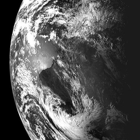
On 25 March 2009, Chandrayaan-1 beamed back its first images of the Earth in its entirety, taken with the TMC, showing Asia, parts of Africa and Australia with India at the centre.
Orbit raised to 200 km
After completion of all major mission objectives, the orbit was raised from 100 km to 200 km on 19 May 2009. The higher altitude enabled studies of orbit perturbations and lunar gravitational field variation, and wider-swath imaging; it was later revealed the change also helped keep the spacecraft's temperature down.
Attitude sensor failure
The star tracker failed in orbit after nine months of operation, attributed to excessive solar radiation. Orientation was subsequently determined using a back-up procedure with a two-axis Sun sensor and Earth-station bearings to update the gyroscopes.
Radar scans
On 21 August 2009, Chandrayaan-1 and NASA's Lunar Reconnaissance Orbiter attempted a bistatic radar experiment using their Mini-SAR radars to detect water ice; the attempt failed as Chandrayaan-1's radar was not pointed at the Moon. However, the Mini-SAR imaged many permanently shadowed regions at both poles, and in March 2010 it was reported to have discovered more than 40 permanently darkened craters near the north pole hypothesised to contain an estimated 600 million tonnes of water ice.
Source: Wikipedia — Chandrayaan-1