Scientific Objective
To provide ranging data for determining accurate altitude of the spacecraft above the lunar surface, determine the global topographical field of the Moon obtain an improved model for the lunar gravity field and supplement the data from terrain mapping camera and hyper-spectral imager payloads Topography is one of the principal measurements required to quantitatively describe any planetary body. When combined with gravity, topography allows the distribution of subsurface density anomalies to be mapped, albeit nonuniquely, yielding information on both the shape and the internal structure of a planet. Such information is fundamental to our understanding of planetary thermal history. The altimetric map of the Moon prepared using the laser ranging instrument carried onboard Chandrayaan-1 spacecraft will help in studying the morphology of large basins and other lunar features, study stress, strain and flexural properties of the lithosphere and when coupled with gravity studies would provide the density distribution of the crust.
Payload Configuration Details
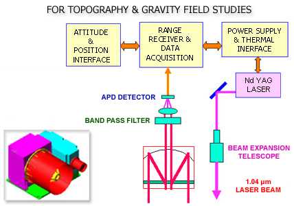
Laser ranging instruments can be operated in either a profiling or scanning mode using pulses of light to illuminate the terrain. A coherent pulse of light at 1064 nm wavelength and pulse width of 10 ns is transmitted to the lunar surface. Some fraction of this light is scattered back in the direction of transmitter where optical receivers collect it and focus in onto a photoelectric detector. The scattering and absorption at distant points can be deduced by analyzing the electric signal from the detector. This payload weighs less than 10kg.
LLRI payload is developed by ISRO


